Course
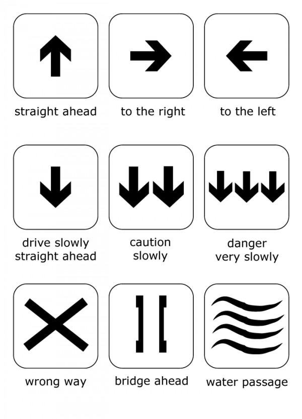
Signs / Course Routing
The marathon course running primarily on public roads, forest roads as well as hiking & biking trails is sufficiently signposted.
Snow conditions permitting, the Trophy training courses will be open for training at the following times:
April till August from 7 am till 7 pm
September from 8 am till 6 pm
October from 9 am till 5 pm
As of July 5th a large part of the course will be signposted and cleared for training. However course sections marked with pink lines in the map you may only bike on the race day! For further details on distances, altitude differences, starting times and limits please see Information.
| Kilometer | Elevation gain | Tarmac | Gravel | Trail | Difficulty level* |
|---|---|---|---|---|---|
| A - 209,7 km | 7047 m | 24,4 % | 62,4 % | 13,2 % | 4 |
| B - 126,8 km | 3758 m | 30,0 % | 62,5 % | 7,5 % | 2-3 |
| C - 79,9 km | 2428 m | 29,4 % | 65,0 % | 5,6 % | 2 |
| D - 57,8 km** | 1973 m | 19,6 % | 60,4 % | 20,0 % | 4 |
| E - 54,9 km | 1719 m | 22,2 % | 62,1 % | 15,7 % | 2 |
| F - 37,3 km | 1044 m | 36,1 % | 45,7 % | 18,2 % | 2 |
| G - 21,8 km | 567 m | 30,4 % | 47,4 % | 22,2 % | 2 |
| Kilometer | Course data |
|---|---|
| A - 209,7 km | Elevation gain: 7008 m Tarmac: 24,4 % Gravel: 62,4 % Trail: 13,2 % Difficulty level*: 4 |
| B - 126,8 km | Elevation gain: 3758 m Tarmac: 30,0 % Gravel: 62,5 % Trail: 7,5 % Difficulty level*: 2-3 |
| C - 79,9 km | Elevation gain: 2428 hm Tarmac: 29,4 % Gravel: 65,0 % Trail: 5,6 % Difficulty level*: 2 |
| D - 57,8 km** | Elevation gain: 1973 m Tarmac: 19,6 % Gravel: 60,4 % Trail: 20,0 % Difficulty level*: 4 |
| E - 54,9 km | Elevation gain: 1719 m Tarmac: 22,2 % Gravel: 62,1 % Trail: 15,7 % Difficutly level*: 2 |
| F - 37,3 km | Elevation gain: 1044 m Tarmac: 36,1 % Gravel: 45,7 % Trail: 18,2 % Difficulty level*: 2 |
| G - 21,8 km | Elevation gain: 567 m Tarmac: 30,4 % Gravel: 47,4 % Trail: 22,2 % Difficulty level*: 2 |
* 1 = easy, 2 = moderate, 3 = demanding, 4 = difficult
** All-Mountain-Course
Note on downloading the GPX data: some GPX files are displayed on the computer as XML files after the download. Please remove the file extension .xml and change it to .gpx, then the data can be processed.


